UK land use laid bare by satellite images
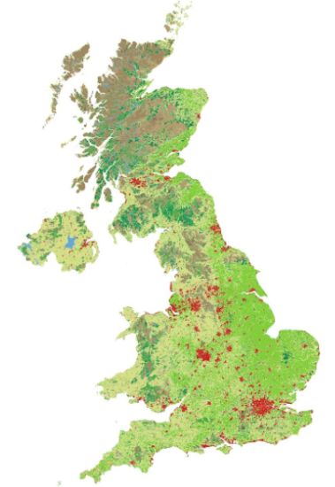
 For the past few decades, satellites have been taking high definition pictures of the United Kingdom and Europe from space. The images are analysed and compared to detailed maps.
The maps were created with Corine (coordination of information on the environment) Land Cover data from 2012 which includes 44 different types of land classification including:
- ‘continuous urban fabric’: used to describe the most built up urban areas
- ‘industrial and commercial units’
- ‘green urban’: golf courses, football pitches, parks etc
- ‘farmland’: pasture, arable land, vineyards, orchards
- ‘natural’: moors, forests, lakes
The work is part of an EU project keeping an eye on changing land use to respond to questions like; is urban sprawl really eating into green belt land? Are forests being decimated? Are grasslands, peatbogs and wetlands under threat?
Where is the most built on land in the UK?
One of the classifications is 'continuous urban fabric' (CUF), applied to areas where 80-100% of the land surface is built on. Up to 20% might be made up of gardens or small parks, but the vast majority is built on.
The City of London is the local authority with the highest proportion of CUF in the country with 98%. However CUF only accounts for 0.1% of the whole of the UK. Another category called 'discontinuous urban fabric', places where between 50% and 80% of the land surface is built on accounts for a mere 5.6%.
A green and pleasant land!?
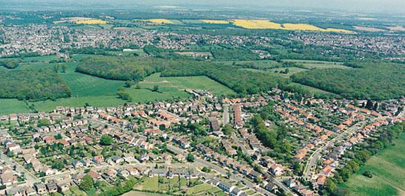
The maps were created by the University of Sheffield. Professor Rae said: “It may feel like a very densely populated urban nation, but the reality is that the vast majority of the land area of the UK is not built on."
“Given that 83% of the population of the UK lives in urban areas it is not surprising that some people hold the opposite to be true. However, from a land cover point of view, the United Kingdom is in fact dominated by pasture and arable land.”
“At a local level things can be very different from the national picture, so it is important to know how land is being used as there are often competing needs. By knowing the makeup of the local landscape it is easier to make informed decisions about how land should be used and plan for the future.”
Ordnance Survey data suggests that all the buildings in the UK - houses, shops, offices, factories, greenhouses - cover 1.4% of the total land surface. Looking at England alone, the figure still rises to only 2%.
So many of our urban areas are greener than you think and the UK is still a green and pleasant land, with more than half the country classed as pasture or arable land. Another startling fact is that buildings cover less of Britain than the land revealed when the tide goes out!
Further information
University of Sheffield - New land cover atlas reveals just six per cent of UK is built on
BBC - How much of your area is built on?
(Thanks for the use of the image at the top of this page, Magnus Manske.)
Sign up to the building bulletin newsletter
Over 48,000 construction professionals have already signed up for the LABC Building Bulletin.
Join them and receive useful tips, practical technical information and industry news by email once every 6 weeks.
Subscribe to the Building Bulletin


Comments
Ychwanegu sylw newydd